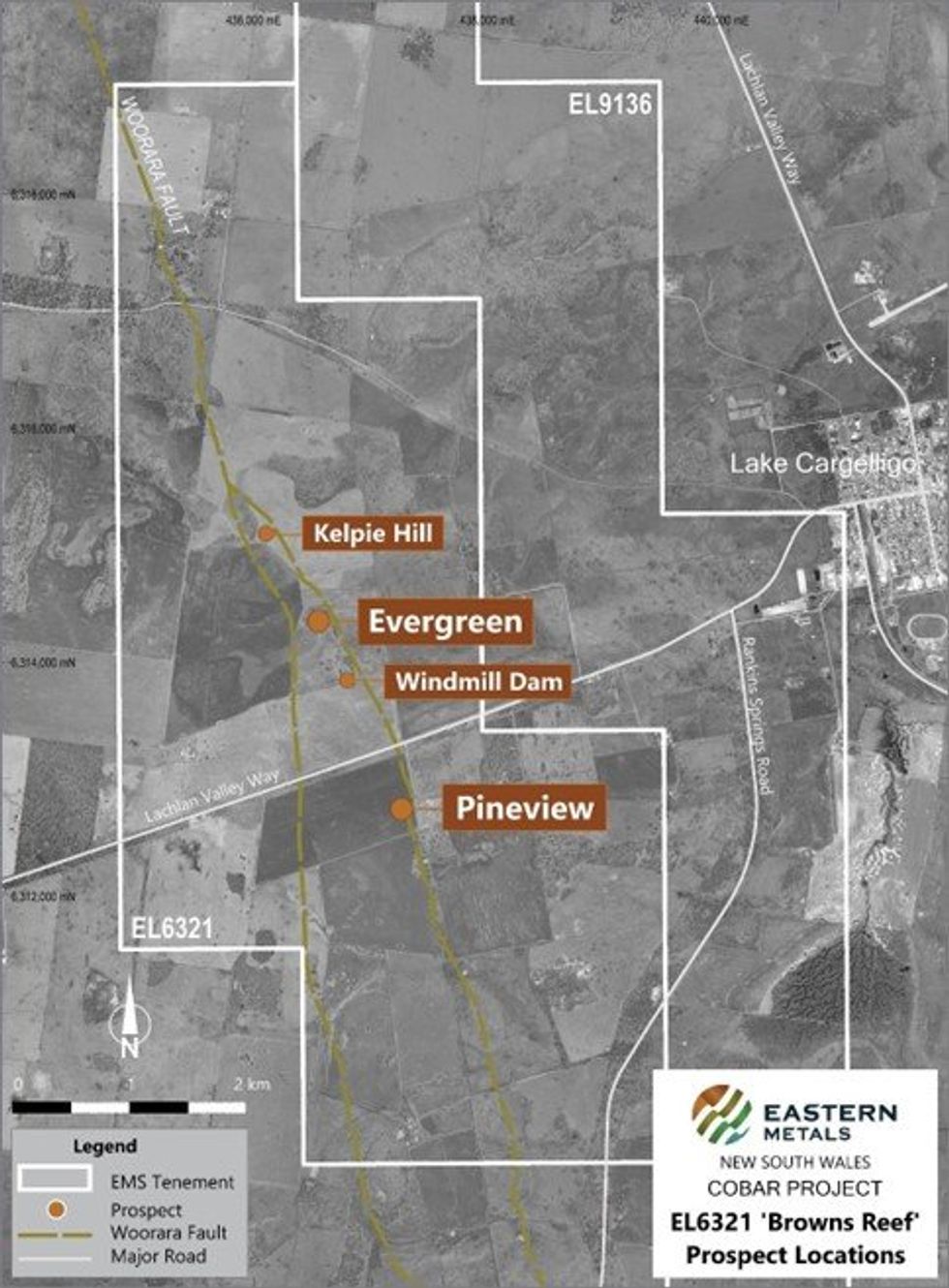
Eastern Metals Ltd (ASX:EMS) (“Eastern Metals” or “the Company”) is pleased to announce that recent fieldwork programs across the 100%-owned EL6321, part of its Browns Reef Project (Figure 1), located in the southern Cobar Basin of NSW, have identified new zones of anomalous base metal mineralisation in the northern portion of the project area.
KEY HIGHLIGHTS
- Assay results from recent fieldwork programs to the north of known high-grade mineralisation at the Browns Reef Project in NSW’s southern Cobar Basin have returned highly anomalous grades from surface rock chip samples.
- Mapping and pXRF traverses along the Woorara Fault, a regional-scale structure related to known mineralisation at the high-grade Pineview and Evergreen zones, have identified new anomalous zones north and south of Evergreen, which have been named ‘Kelpie Hill’ and ‘Windmill Dam’ respectively.
- Planning is underway to update and extend the existing drilling approvals for Evergreen to include these prospects, along with an Induced Polarisation (IP) survey.
- Three land access agreements have now been secured for EL9136 (Bothrooney), with reconnaissance fieldwork on this tenement scheduled for mid-June 2024.
The fieldwork programs were completed in April 2024 and May 2024 and focused on the Woorara Fault, to the north of the known high-grade Pineview and Evergreen zones at Browns Reef1. A JORC Table 1 is provided at Appendix A.
Commenting on the results, Eastern Metals’ Chief Executive Officer Ley Kingdom said: “These are highly encouraging initial results from our fieldwork programs, which have confirmed the ability of mapping and soil pXRF analysis to identify geochemical trends within EL6321.
“What’s even more encouraging is that these programs have highlighted new anomalous areas along the prospective Woorara Fault. These new areas include Kelpie Hill and Windmill Dam, located to the north and south of the known high-grade mineralisation zone at Evergreen.
“Kelpie Hill and Windmill Dam will be high-priority target areas for upcoming exploration programs, with IP surveys and drilling planned to test whether these represent a continuous zone of mineralisation between Pineview and Evergreen, and potentially, a northern extension of Evergreen.”
Figure 1: Location of EL6321, Browns Reef and the Pineview, Evergreen, Kelpie Hill & Windmill Dam prospects.
EL6321 Browns Reef Overview
Browns Reef (EL6321) is an ‘advanced exploration project’ located 5km west of Lake Cargelligo in the southern Cobar Basin, NSW. It is a structurally controlled, polymetallic system extending along the inferred Woorara Fault and the Preston Formation and Clements Formation contact.
Fieldwork within EL6321 was undertaken in April 2024 and focused on the area between the Lachlan Valley Way Road and the North Uabba Road. The program was aimed at ground truthing and, where possible, adding to the auger and rotary air blast (RAB) hole data and geological mapping originally acquired by the Electrolytic Zinc Company of Australasia Ltd (EZ) in the 1970s.
Most paddocks in the area have been cropped or cultivated at some stage and outcrop is rare; however, gossanous material is commonly evident in stone raked piles throughout the entire strike length of the inferred Woorara Fault and Preston-Clements contact, defining a north-northwest trending zone.
In addition, ground reconnaissance revealed that gossanous float material was often present scattered along the approximate trend of the inferred mineralised zone; it is believed that significant displacement of this float due to farm activities has not taken place. In total, 28 samples of gossanous rock material were collected for assaying, comprising an average of 1-2kg per sample from multiple pieces of surface float.
A second field trip was conducted in mid-May 2024 utilising a SciAps X555 portable X-ray fluorescence analyser (pXRF) to conduct soil readings every 10 metres along east-west traverses. Line spacing was informed based on real-time results and the previous day’s visual assessment of geochemical dispersion of lead. The program was used to test the pXRF capabilities for detecting lead in soils and identifying geochemical trends across the different lithologies at Browns Reef.
The Tertiary basalt coverage within EL6321 is a considerable masking lithology that potentially covers portions of the northern extension of the Browns Reef mineralisation. The pXRF demonstrated that soil anomalism of lead (Pb) and arsenic (As) were readily traceable within the soil profiles and decreasing Pb results could effectively map out the basalt and Clements Formation contact zones. Rock chip samples paired with the pXRF readings were able to distinguish further prospective zones to the south and north of the Evergreen deposit.
Of particular note are two new prospective areas now designated “Kelpie Hill” and “Windmill Dam”. Kelpie Hill is located approximately 700 metres to the northwest of Evergreen, and Windmill Dam is 500 metres to the southeast.
Click here for the full ASX Release
This article includes content from Eastern Metals, licensed for the purpose of publishing on Investing News Australia. This article does not constitute financial product advice. It is your responsibility to perform proper due diligence before acting upon any information provided here. Please refer to our full disclaimer here.
Credit: Source link


